
· Goher K · Mountaineering · 26 min read
Haramosh 7,409m Expedition: Grueling Karakoram Alpine Crux Ascent
Complete expedition chronicle of Haramosh (7,409m). Learn how to navigate the notorious Haramosh La pass, deadly ice seracs, and unpredictable blizzards.
Haramosh Peak (7,409m / 24,308ft) is a formidable, technically brutal mountain in the Karakoram Range of Gilgit-Baltistan, Pakistan, towering between the Chogo Lungma and Mani glaciers. Renowned in mountaineering lore for its treacherous avalanche chutes, unpredictable blizzards, and vertical seracs, it demands exceptional alpine endurance. The Haramosh La Traverse (approx. 5,150m)—connecting Arandu in Baltistan to Sassi in the Gilgit Valley—is one of the most perilous glacial crossings in the world. This expedition chronicle documents the independent, non-commercial alpine traverse and push toward the 7,409m apex led by Goher K, navigating -30°C frostbite conditions, a porter mutiny, deep snow trail-breaking, and the harrowing descent across the Mani Glacier.
The Golden Awakening: Preparation and Philosophy in Arandu
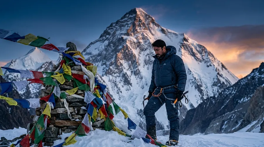
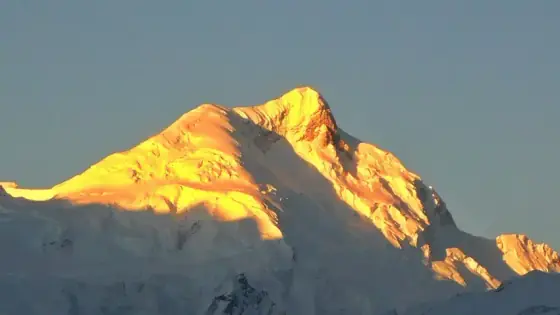
When the first rays of the sun strike the Karakoram, they don’t just illuminate the landscape; they set it on fire. Standing before Haramosh (7,409m) at sunrise is like witnessing the awakening of a golden titan. But as beautiful as this mountain is from a distance, up close, it is an unforgiving beast that tests every fiber of your physical and psychological resilience. Often overshadowed by its more famous neighbors, Haramosh offers a unique blend of extreme beauty and deadly challenge.
       [ Arandu Gateway: Heritage Hammam & Winter Shoe Outreach ]
                                 │
       [ Chogo Lungma Glacier Traverse ➔ Bolocho Camp Ascent ]
                                 │
       [ Haramosh La Command Base Camp Established (5,150m, -30°C) ]
                                 │
       [ Technical Cruxes: Mani Ice Wall & Exposed Ridge Camps ]
                                 │
       [ Midnight Summit Push: 10-Step Pacing to 7,409m Apex ]
                                 │
       [ Haramosh La Pass Mutiny & Breaking Trail on Mani Glacier ]
                                 │
       [ Kutwal Lake Relief ➔ Descent through Iskere to Sassi ]
The Architect’s Philosophy: No Commercial Expeditions
Most mountaineers rely on commercial tour operators, letting agencies handle the headaches of logistics and itinerary planning. But I do not buy pre-packaged adventures; I architect them.
For me, an expedition begins months before my boots touch the ice. I spend countless hours doing my own rigorous R&D, analyzing topographical maps, and plotting custom routes on Google Earth. I design the entire project from scratch and deal directly with the local communities, negotiating and hiring porters and guides face-to-face. This philosophy isn’t just about independence—it is about taking absolute ownership of both the triumphs and the life-threatening risks. Out here, there is no safety net provided by an agency. Your survival depends entirely on the meticulousness of your own architecture.
Heritage & Humanity: From Ancient Hammams to Winter Shoes
Our journey began in Arandu, the remote Balti village that serves as the gateway to the Chogo Lungma Glacier. Before stepping into the freezing wild, I was invited to freshen up in a remarkable piece of local heritage—a 200-year-old hammam.
Brushing my teeth and washing my face in this historic stone structure felt like stepping back in time. It was a humbling reminder of the deep, enduring culture of the Balti people, whose ancestors have survived in this harsh environment for centuries.
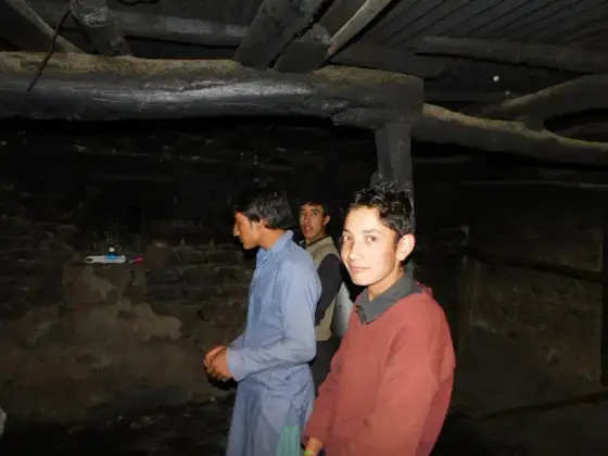
Tucked into my backpack for every major expedition are two or three specific lightweight shirts. They aren’t fancy, and they certainly aren’t new—I have been wearing them on high-altitude trails for over a decade. In mountaineering, gear isn’t just fabric and stitching; when a piece of clothing has absorbed the sweat of dozens of high passes and weathered freezing gales across the Karakoram, it becomes trusted armor.
By sheer coincidence—or perhaps an unspoken ritual—every single expedition I have launched out of Arandu begins with me wearing that very same shirt on Day 1. It is a quiet personal trademark: long before the crampons go on and the technical layers are zipped up, that familiar shirt serves as a grounding anchor between the comfort of home and the brutal wilderness ahead.
Supporting the local communities along our route is central to how I plan every expedition, but in a valley as remote as Arandu, logistics require rigorous advance preparation. You cannot simply arrive in a distant Karakoram village and figure out requirements on the spot—there are no markets, and supplies are days away.
About a week before departing from Islamabad, I established direct communication with the local school teachers in Arandu to gather the exact requirements and assess what the children needed most for the harsh winter ahead. Guided by the teachers’ feedback, I procured and arranged sturdy winter shoes and essential supplies entirely from Islamabad, packing them alongside our expedition gear.
When we reached Arandu before beginning our trek toward the glacier, we held the distribution for the school children. The scene was both heartwarming and intense—in the eager rush for warm shoes, a few children became emotional when matching sizes proved challenging. It was a deeply humbling moment that stayed with me throughout the climb: while we pursue high-altitude summits, the real resilience belongs to the families and children enduring everyday life in these unforgiving valleys.
The Traverse Begins: Arandu to Laila Base Camp
Leaving the village behind, we stepped onto the massive Chogo Lungma Glacier. We navigated the complex terrain, pushing through Bolocho Camp, slowly gaining altitude. The sheer scale of the Karakoram surrounded us as we approached Laila Peak Base Camp, a crucial stepping stone before the notorious Haramosh La. Sharing this initial route with the Golden Peak of Spantik, Haramosh stands as the ultimate guardian of this region.
Psychological Crux: Conquering the Ghost of Bolocho
Mountaineering is as much a mental game as a physical one. Just a month and a half prior to Haramosh, I had suffered a severe electrolyte imbalance and a minor foot fracture on a different trek due to extreme dehydration. I had pushed myself so hard that upon returning to Islamabad, my legs completely gave out the moment I stepped out of my car. I was bedridden, unable to stand, for a week.
As we navigated the complex, steep terrain near Bolocho Camp, we encountered a terrifyingly sharp descent over the glacier. Looking down the sheer drop, a sudden, paralyzing thought gripped me: What if my knees give out again? What if that electrolyte imbalance returns right here, on the edge of the abyss?
For a few tense moments, the trauma of that recent physical failure threatened to derail my focus. But the mountains demand absolute presence. I had to consciously silence the doubt, reasoning with myself that my body had recovered. It was a fierce internal dialogue, but within half an hour, I had locked that fear away in a mental box, and it didn’t surface again for the rest of the expedition. It was a stark reminder that before you conquer the mountain, you must first conquer your own mind.
Establishing Command: Haramosh La Base Camp at 5,150m
This was not a commercial group venture backed by large corporate sponsors. It was our own raw, personal expedition—conceived, financed, and executed between two close friends who chose to tackle the grueling East-to-West traverse from Arandu across the Chogo Lungma Glacier.
On August 17, 2017, battered by relentless winds and surrounded by blinding white amphitheaters of ice, we reached the col and established our Base Camp directly on Haramosh La (approx. 5,150m). Perched on this high, exposed pass between two massive mountain systems, this camp served as our forward command post and launchpad into the vertical unknown.
The environment was brutal. The last time I checked our thermometer at Base Camp, the mercury had already plummeted to an astonishing -30°C—and that was during daylight hours. With windchill kicking in, the upper reaches were a deep-freeze that drained body heat in minutes.
Route Architecture: 3D Topographic and Satellite Analysis
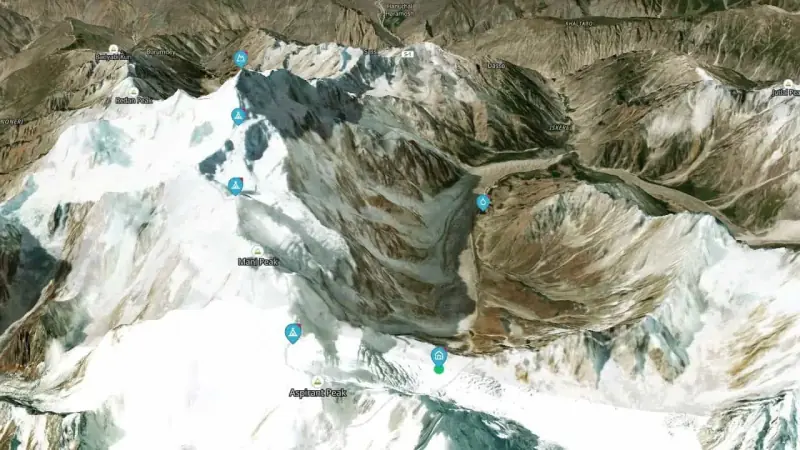
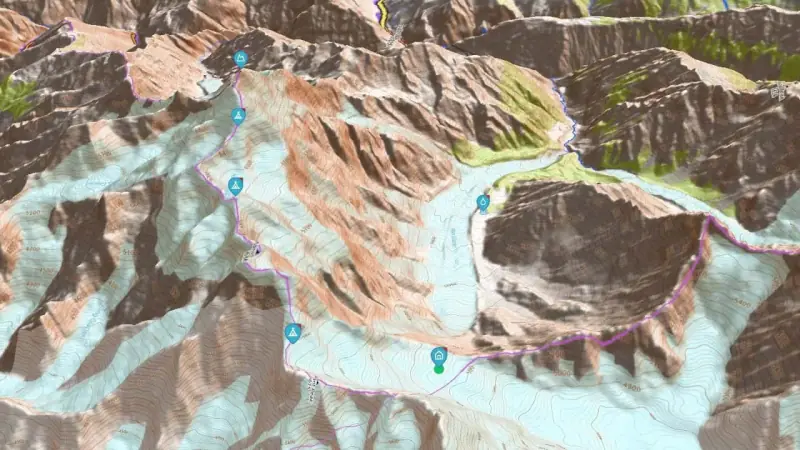
Plotting our trajectory from Haramosh La (5,150m) to the 7,409m apex reveals the complex geometry required to negotiate the mountain’s north-eastern defenses. In mountaineering, a straight line is almost always a deadly line.
<!-- Navigation Arrows -->
<button onclick="toggleMapSlide()" class="absolute left-3 top-1/2 -translate-y-1/2 bg-black/60 hover:bg-black/90 text-white p-2 sm:p-2.5 rounded-full backdrop-blur-sm transition border border-white/20 cursor-pointer shadow-lg" aria-label="Previous Slide">
  <svg class="w-5 h-5" fill="none" stroke="currentColor" viewBox="0 0 24 24"><path stroke-linecap="round" stroke-linejoin="round" stroke-width="2.5" d="M15 19l-7-7 7-7"></path></svg>
</button>
<button onclick="toggleMapSlide()" class="absolute right-3 top-1/2 -translate-y-1/2 bg-black/60 hover:bg-black/90 text-white p-2 sm:p-2.5 rounded-full backdrop-blur-sm transition border border-white/20 cursor-pointer shadow-lg" aria-label="Next Slide">
  <svg class="w-5 h-5" fill="none" stroke="currentColor" viewBox="0 0 24 24"><path stroke-linecap="round" stroke-linejoin="round" stroke-width="2.5" d="M9 5l7 7-7 7"></path></svg>
</button>
Fig A: 3D Satellite Aerial View — True-scale glaciated terrain from Haramosh La Base Camp (5,150m) across the upper basin to the 7,409m summit.
The High-Altitude Crucible: Ice Walls, Seracs and Gadget Ban
My core philosophy in expedition architecture is strict discipline over vertical gain: never exceed 600 to 700 meters of elevation in a single day above 5,000m. Above the clouds, pacing is the only barrier between calculated success and fatal altitude sickness.
However, the mountain immediately tested our resolve. From Haramosh La, we pushed toward Camp I (approx. 5,650m) across the lower snow plateau at the threshold of the upper glacier basin. It was here that the altitude and punishing cold took their toll on our two-man partnership. My friend, who had journeyed all the way from Arandu with me, reached his absolute physical threshold. Recognizing his limits, he made the courageous and safe call to hold back and remain at Base Camp, supported by one of our porters who stayed behind with him to manage camp life and maintain a safe base.
From that point onward, the summit bid was entrusted to a tight-knit three-man rope team: myself, our lead guide, and our high-altitude porter.
Continuing the staged push, our small rope team faced the formidable Mani Ice Wall to reach Camp II (approx. 6,200m). On the topographic model, the distance between Camp I and Camp II appears as a wide, sweeping arc rather than a direct heading. In alpine realities, direct ascents out of the basin are barred by a heavily shattered icefall and yawning crevasse fields. Pushing straight up invites catastrophic serac collapse, forcing a broad bypass across the upper glacier basin.
Barring our direct access to the ridge stood the notorious Mani Ice Wall—a daunting, near-vertical 700-foot barrier of blue ice. Tackling it demanded unrelenting technical climbing: hauling up fixed lines, driving ice screws with numb fingers, and fighting sheer gravity before establishing Camp II on the high shoulder.
Because Mani Peak forms the primary buttress of Haramosh, traversing its high crests was an unavoidable necessity to gain the upper mountain. Moving along this exposed ridge beneath unstable seracs, we pushed to establish our final High Camp III (approx. 6,700m) directly below the East Ridge. As we occupied the camp, heavy and unyielding snowfall began piling up. The slopes were loaded with fresh, wind-drifted powder—a hair-trigger invitation for catastrophic slab avalanches.
It was here that our guide and porter enforced a strict, non-negotiable gadget ban.
Survival superseded documentation. With daytime temperatures hovering around -30°C and dropping drastically at night, batteries died instantly and electronics froze solid. More importantly, with unstable seracs hanging above and knee-deep snow beneath us, we needed two free hands for ice axes, total balance on crampons, and zero distractions. Fumbling with gloves to handle drones or professional cameras was strictly forbidden; every idle second invited severe frostbite or missing an avalanche warning. Every foot gained on these upper pitches was recorded not on memory cards, but etched directly into raw instinct and survival memory.
The Midnight Push: The 10-Step Template to the 7,409m Apex
Just past midnight, under the bitter black chill of high altitude, we launched our final bid from High Camp III along the exposed East Ridge. At over 7,000 meters, every breath burns like dry ice, and the sheer physical exhaustion threatens to shut your muscles down entirely. In the death zone, solid food is near-impossible to digest, so survival came down to what was stripped down to the bare essentials inside my summit daypack: dense energy bars and a concentrated energy drink.
Sipping that energy drink mid-climb delivered a lifeline of rapid glycogen and electrolytes directly into my bloodstream. It provided the vital spark my body desperately needed to stay responsive.
To maintain total command over my body and keep exhaustion from turning into panic, I paired that physical fuel with a strict mental rhythm—a pacing template to govern the pain:
Ten steps forward, followed by a strict ten-second pause. Ten steps forward, ten seconds pause.
Breaking down the impossible mountain into small, disciplined 10-step algorithms kept the mind focused and forced oxygen back into burning lungs. We repeated this relentless rhythm for hours in the dark, cutting steps along knife-edge drop-offs where thousands of feet of empty air plummeted on either side.
And then, as the morning sun ignited the frozen world around us, the steep ridge finally flattened out.
At 7,409 meters (24,308 ft), the three of us—myself, my lead guide, and our high-altitude porter—stood together on the summit of Haramosh.
In that singular moment, an inexplicable phenomenon took over: the soul-crushing fatigue that had weighed down every muscle simply vanished. Looking out across the boundless ocean of Karakoram giants, it felt as though the exhaustion had never existed—an overwhelming, surreal lightness washed over my senses. Yet, beneath that brief euphoria lay the cold mountaineering truth: we were standing on a fragile, wind-scoured apex, and the summit is only the halfway mark. We anchored our ropes, took in the silent majesty of the Karakoram, and immediately prepared for the perilous descent back into the storm.
Descent into the Abyss: Glacial Mutiny at Haramosh La
Reaching the 7,409m summit was an endurance of physical will; the descent off Haramosh La into the Haramosh Valley was an outright test of psychological survival.
After safely descending from the high camps back to our Base Camp at Haramosh La, we were reunited with my friend and our camp porter. With our main gear accessible again at base camp, the mountain gave us no time to celebrate. We woke up trapped beneath 3 to 4 feet of fresh, unstable snow. Our mission to complete the East-to-West traverse meant dropping off the western side of the pass, plunging down the treacherous Mani Glacier into the valley toward Gilgit.
Looking over the edge of the pass down the colossal drop, the porters froze. Terrified by the severe avalanche risk loaded on the steep gullies, they outright refused to descend. They brought up the tragic memory of my nephew’s fatal accident on a previous expedition, pleading with me to retreat back down the way we had come through Arandu. It was a full-blown mutiny on the ice.
I stood my ground: “We have survived critical expeditions before. We are not turning back to Arandu. We will descend Haramosh.”
Breaking the Trail Down the Fractured Mani Glacier
Standing on the edge of the pass, the drop into the valley below was dizzying. Before taking a single step down, we assessed the slope—a vertical maze of unstable cornices, loaded snowpack, and hidden crevasses.
With the team paralyzed by fear at the edge of the pass, speeches were useless—only action could break the deadlock. I stepped out onto the steep decline and took point.
Plunging into waist-deep, unstable snow, I began breaking trail down the menacing slopes of the Mani Glacier. Seeing me commit to the descent line, the porters had no choice but to follow.
However, pure survival mode triggers chaotic panic. As the slope steepened and fear mounted on the descent, the porters resorted to desperate measures to lighten their loads and move faster: they began hurling my duffel bags and expedition gear down the icy slopes. It was a heavy financial and material loss, but in the mountains, gear is replaceable; human lives are not.
The Serenity of Kutwal Lake and Scars of Survival
After days of adrenaline, mutiny, and freezing survival, the landscape finally shifted. We descended into the Haramosh Valley and were greeted by the astonishing beauty of Kutwal Lake (Haramosh Lake).
The vibrant green meadows and the deep turquoise waters felt like a mirage. It was the ultimate relief—a serene paradise waiting at the end of a terrifying gauntlet.
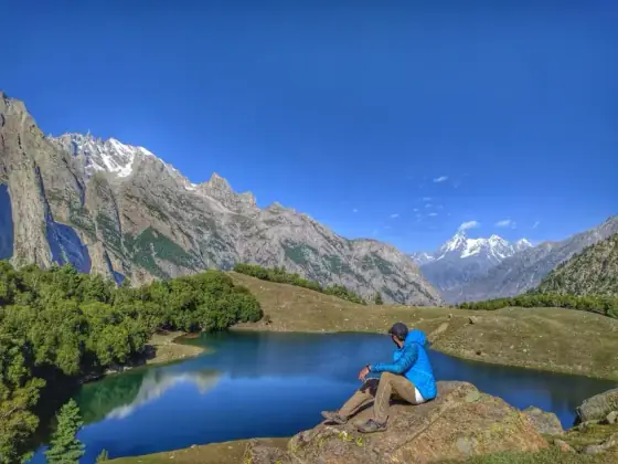
Sitting on the shores of Kutwal Lake, with the deafening roar of the glacier finally behind us, the adrenaline that had fueled my survival began to dissipate. For the first time in days, I untied my rigid mountaineering boots and peeled off my heavy thermal socks.
It was only then that the mountain revealed the silent physical toll of that brutal descent.
The relentless pounding against the hard toe-boxes while braking down thousands of vertical feet of steep ice and waist-deep snow had taken its price: three middle toenails on my left foot were completely blackened and dead. Within days, all three would detach entirely. In high-altitude mountaineering, summits are not won without a tax; some prices are paid in gear, and others are paid in flesh and blood. Those blackened nails were the quiet, permanent battle scars of Haramosh.
The Price of Purity: The Haramosh Milk Incident
As we continued our descent towards Sassi, we encountered the warm hospitality of the local villagers. Happy to see guests, they offered us fresh, pure milk.
However, my “city stomach” was completely unprepared for just how rich and unadulterated this milk was. Having survived extreme altitude, heavy snowfall, and a mutiny on a glacier, the real struggle began in the valley: my stomach gave up. I had to sprint to the washroom a couple of times! It was a hilarious, humbling end to an epic journey.
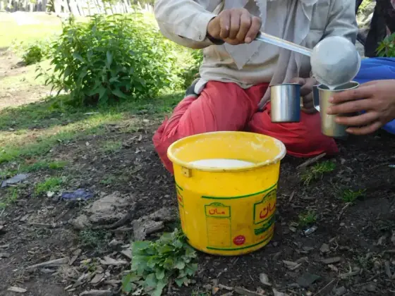
Our journey ended safely at Sassi, completing one of the most demanding traverses and climbs in the Karakoram.
Haramosh Expedition Strategy Ledger and Fact File
High-altitude success requires balancing rigorous physical conditioning with unwavering mental resilience and deep respect for Karakoram conditions.
Strategic Expedition Takeaways
- Mental Resilience Over Gear: Gear can be abandoned or replaced, but mental fortitude is irreplaceable. When panic threatens the team, the leader must maintain absolute composure and break the trail by personal example.
- Deep Snow Descent Tactics: Navigating 3 to 4 feet of fresh powder on a steep incline requires meticulous foot placement. Test every step before committing weight and steer clear of loaded avalanche funnels.
- Independent Architecture Accountability: Independent alpine ventures offer freedom from agency constraints, but demand total responsibility for route planning, porter safety, and emergency contingency protocols.
- Acclimatization Discipline: Never exceed 600 to 700 meters of elevation gain per day above 5,000 meters. Pacing and scheduled rest are non-negotiable barriers against acute mountain sickness.
- Valley Rehydration Protocol: Exercise caution when re-introducing rich local dairy after weeks of dehydrated high-altitude rations.
Haramosh Expedition Fact File
| Parameter | Expedition Specification |
|---|---|
| Mountain Name | Haramosh Peak (Haramosh I / Peak 58) |
| Elevation | 7,409 meters (24,308 ft) |
| Mountain Range | Karakoram (Rakaposhi-Haramosh Sub-range) |
| Location | Gilgit-Baltistan, Pakistan (~65 km east of Gilgit) |
| Route Profile | Full Alpine Traverse: Arandu (Baltistan) ➔ Haramosh La ➔ Sassi (Gilgit) |
| High Pass Elevation | Haramosh La Col: approx. 5,150 meters (16,896 ft) |
| Key Glacial Systems | Chogo Lungma Glacier (East) & Mani Glacier (West) |
| Base Camp Temperatures | Recorded at -30°C (daylight hours with windchill) |
| Expedition Style | Pure Independent Alpine Style (Unassisted R&D, No Tour Agency) |
| Prime Climbing Window | Mid-July to Late August |
| Historical Summit Success Rate | Approximately 30% (High failure rate due to severe avalanche risk) |
Frequently Asked Questions About Haramosh Peak
What is the exact altitude and location of Haramosh Peak?
Haramosh Peak (also known as Haramosh I) stands at an elevation of 7,409 meters (24,308 feet) in the Karakoram Range of Gilgit-Baltistan, Pakistan. It lies roughly 65 kilometers east of Gilgit, towering between the Chogo Lungma and Mani glaciers.
How difficult is the Haramosh La Traverse compared to other Karakoram passes?
Haramosh La (approx. 5,150m) is considered one of the most treacherous and technically demanding passes in the Karakoram. Unlike standard trekking passes like Gondogoro La, Haramosh La involves heavily crevassed glaciers, steep icefalls, severe avalanche risks, and extreme exposure, requiring full technical mountaineering equipment including crampons, ice axes, and fixed ropes.
What is the best season to attempt Haramosh Peak and the La Traverse?
The optimal climbing and trekking window is during mid-summer, typically from mid-July to late August. Earlier in the season, heavy winter snowpack increases avalanche hazards, while by September, temperatures drop drastically and late-season snowstorms make the high camps and pass crossings impassable.
What are the primary climbing routes to Haramosh Peak?
The two primary historical approaches are from the Gilgit side via the Haramosh Valley (Sassi/Kutwal) and the eastern approach from Baltistan via Arandu and the Chogo Lungma Glacier. Modern alpine expeditions often attempt the traverse from Arandu to Haramosh La before pushing up the East Ridge toward the 7,409m summit.
What are the biggest hazards on Haramosh Peak?
The greatest hazards on Haramosh are catastrophic slab avalanches, unstable hanging seracs, and severe crevasse fields. The mountain is infamous for massive snow accumulation and unpredictable weather shifts, which have historically caused high failure rates and tragic accidents on its upper flanks.
How fit do you need to be for Haramosh La, and is it suitable for beginners?
Haramosh is strictly not suitable for beginners. It demands advanced high-altitude endurance, technical ice and rock climbing competency, self-arrest skills, and extensive experience navigating glaciated terrain above 5,000 meters in sub-zero alpine conditions.
What gear is essential for crossing Haramosh La and high camps?
Essential equipment includes rigid mountaineering boots, technical crampons, ice axes, harnesses, dynamic climbing ropes, snow pickets, ice screws, four-season expedition tents, sub-zero sleeping bags rated for -30°C or lower, and comprehensive glacier rescue kits.
How does the route connect from Haramosh La to Kutwal Lake?
From the crest of Haramosh La (5,150m), the route descends precipitously over the fractured Mani Glacier. Trekkers negotiate complex moraines and steep snow couloirs before the glacier levels out, leading into the lush high-altitude meadows surrounding Kutwal Lake (Haramosh Lake) and continuing down toward Iskere and Sassi.